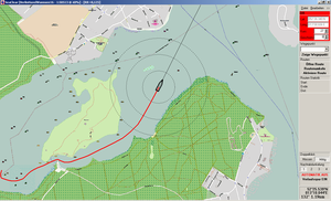
Offline-Chartsets
We continuosly produce new chart folios that can be used offline on a wide range of hardware with various programms for navigation
At the moment we have about 300 folios of both open sea and rivers available. At the moment charts are available in the following formats: KAP, WCI, PNG, JPR, CAL.
More to come soon
Offline charts are updated frequently
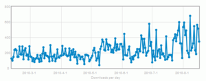
Download
At peak times we have more that 60 downloads per day.
Biggest traffic in one week: 2500 downloads wit 20 GBs.
All in all 50000 downloads with over 500 GBs.